
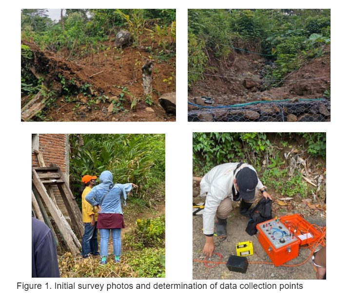
The global change in environment increased the potential of natural disaster around the world. To deal with the situation, we need to do preventive effort through understanding how nature works. This is also inline with the goals mentioned in Sustainable development Goals (SDGs) which are to do an action on climate change (Goals 13. Climate action) and how we (as humans) protect, restore and promote sustainable environment including managing forest and the areas (goals 15: Life on land). In the form of community practices, Dr. Siti Zulaikah and a team from the Physics Department, Universitas Negeri Malang, have explored one of the district areas Watulimo Village, Treanggalek, named Ngruno. Topographically, Ngruno is located in an area of limestone mountains and intrusive igneous rocks [1]. The condition of Ngruno is that the population is quite dense, living on a hillside area with a slope. One of the locations in Ngruno is currently experiencing a moving ground condition. There are three houses/KK that have been evacuated in the area[2]–[4]. To understand the movement of a fairly large land mass ( ± 1 hectare), with conditions that are thought to be dangerous, it is very important to map the slip surface in that area. Mapping of sliding areas aims to provide affected residents with insight into the conditions and predictions of the moving land and as a basis for decision making for the government and local residents. An initial survey of this area was carried out on June 28 2023.
By mapping and better understanding slip areas and potential landslides, local authorities and communities can take more effective prevention and mitigation measures to reduce disaster risk. Preventive actions such as safe land use regulations, infrastructure improvements, and emergency evacuation plans can be prepared based on an understanding of landslide patterns and characteristics in the area.
The implementation method of this community service is divided into several stages as follows: (1) Survey and communication stage with the regional government and local community; (2) Preparation of geoelectric tools; (3) Collecting field data using the geoelectric method; (4) Field data processing; (5) Creating a distribution map of landslide-prone areas integrated with ArcGis. These five stages can be described as follows:
From the measurement results, the resistivity pattern of the soil/rock layer below the surface of the moving soil area can be mapped as we can see in the Figure 1.
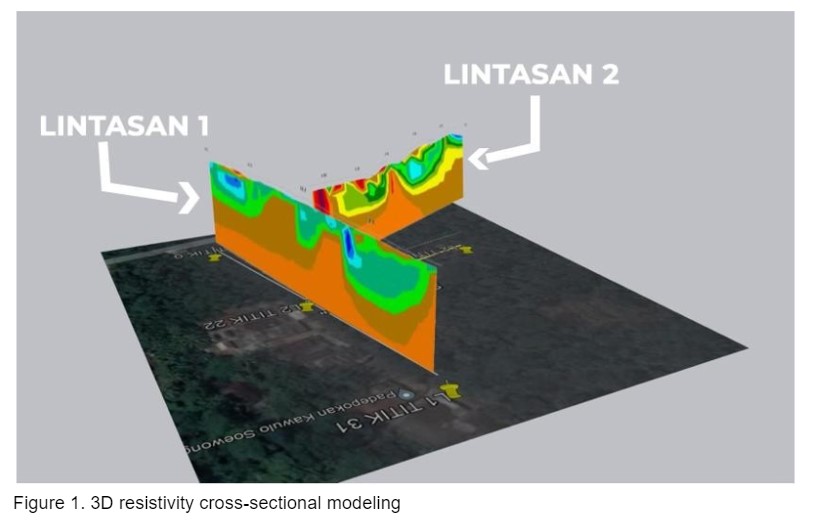
The processing results in pass 1 of the color image seen in the cross-section of the pseudosection can be grouped into resistivity values and rock types as in table 1, while the pseudosection depth of the first pass obtained reached 33.8 meters. Track 1 is a track that runs across the wall of the slip surface on track 2. On this track, the lithology found in the upper layer is dominated by clay rock and there is some surface water with a resistivity range between 0.036 Ω -20.7 Ω with a depth of up to 6.38 meters. This is reinforced by the presence of a small river-like flow that passes through the track. 1 this. This route also has a low elevation at an altitude of between 360-365 meters above sea level. The modeling of path 1 can be seen in Figure 2, while path 2 can be seen in Figure 3.
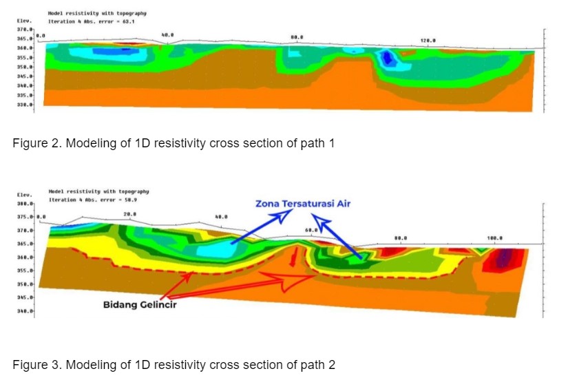
The results of processing track 2, which has a track length of 145 meters, obtained data to a depth of 24 meters below the surface. This route has a higher elevation than route 1 with an elevation ranging from 360-375 meters above sea level. On track 2, slip areas were detected at depths varying from 9.26 meters to 24 meters below the surface with resistivity values ranging from 101 Ω – 496 Ω in the form of breccia from the Mandalika rock formation. The layer above the slip plane consists of soil, clay, wet clay and clay rock which can store water with a resistivity value of 0.036 Ω – 101 Ω and thickness ±15 meters. When it rains, this layer cannot properly transmit water downwards, causing water to accumulate which can cause landslides [5], [6]. Meanwhile, the lower layer of the slip plane consists of a layer that tends to be hard, consisting of sandstone and breccia from the Mandalika rock formation and the Arjosari rock formation.
From the measurement results and discussion, it can be concluded that several important and recommended mitigation steps are as follows: (a) slip area was found on track two with depth between. Slip plane was found on track two with a depth of 9.26 meters to 24 meters below the surface with resistivity values ranging from 101 Ω – 496 Ω in the form of breccia from the Mandalika rock formation with a slope of around 20° . The layer above the slip plane consists of soil, clay, wet clay and clay rock which can store water with a resistivity value of 0.036 Ω – 101 Ω and a thickness of ±15 meters; (b) by considering the condition of the slip surface, landslides can be predicted to occur if there is rainfall with infiltration water triggering the slip surface. To overcome this possibility, the following steps are recommended: (a) for long-term interests, it is deemed safest to evacuate affected residents; (b) if the recommendation is deemed difficult, it is necessary to dredge the mass of land to divert it to another location, starting from track axis 2 to the edge of the road to anticipate movement that could possibly hit residents’ houses, and (c) in this area, it is also recommended to install piles that penetrate the slip area and install a concrete boundary wall.
References

[1] A. R. Putri, A. Widodo, And M. S. Purwanto, ‘Investigation Of Landslides And Floods Utilizing A Geographic Information System (A Case Study: Trenggalek Regency, East Java)’, Iop Conf. Ser. Mater. Sci. Eng., Vol. 1115, No. 1, P. 012011, Mar. 2021, Doi: 10.1088/1757-899x/1115/1/012011.
[2] ‘Longsor Dan Banjir Di Trenggalek, Dua Akses Menuju Kecamatan Munjungan Terputus Total’, Tribunmataraman.Com.
Https://Mataraman.Tribunnews.Com/2022/11/04/Longsor-Dan-Banjir-Di-Trenggalek- Dua-Akses-Menuju-Kecamatan-Watulimo-Terputus-Total (Accessed Nov. 16, 2022).
[3] ‘Tinjau Bencana Di Watulimo, Bupati Trenggalek Prioritaskan Terbukanya Akses Menuju Titik Bencana - Tribunmataraman.Com’. Https://Mataraman.Tribunnews.Com/2022/11/04/Tinjau-Bencana-Di-Watulimo-Bupati- Trenggalek-Prioritaskan-Terbukanya-Akses-Menuju-Titik-Bencana (Accessed Nov. 16, 2022).
[4] ‘Tinjau Lokasi Bencana Di Watulimo, Bupati Trenggalek Prioritaskan Terbukanya Akses Ke Titik Bencana’. Https://Www.Msn.Com/Id-Id/Berita/Other/Tinjau-Lokasi-Bencana- Di-Watulimo-Bupati-Trenggalek-Prioritaskan-Terbukanya-Akses-Ke-Titik-
Bencana/Ar-Aa13jhq5 (Accessed Nov. 16, 2022).
[5] I. K. A. Putra And I. G. Wardika, ‘Analisis Kerentanan Lahan Terhadap Potensi Bencana Tanah Longsor Pada Wilayah Kaldera Batur Purba’, Media Komun. Geogr., Vol. 22, No. 2, P. 208, Dec. 2021, Doi: 10.23887/Mkg.V22i2.36925.
[6] A. Susilo, F. Fitriah, Sunaryo, E. T. Ayu Rachmawati, And E. A. Suryo, ‘Analysis Of Landslide Area Of Tulung Subdistrict, Ponorogo, Indonesia In 2017 Using Resistivity Method’, Smart Sustain. Built Environ., Vol. 9, No. 4, Pp. 341–360, Jan. 2020, Doi: 10.1108/Sasbe-06-2019-0082.
![]()